A long time coming, but I finally wrote up slightly more human readable definition of the XML metadata format.
http://travellermap.com/doc/metadata
It doesn't explain everything, but should cover everything you actually need: borders, routes, allegiances, subsectors, labels, stylesheets, etc.
Ω
Showing posts with label metadata. Show all posts
Showing posts with label metadata. Show all posts
2014-11-22
2013-07-26
It's here
The stuff I promised in my last post is now live.
Ω
- Cleaned up API URLs and "semantic" URLs
- You can now POST MSEC metadata to the poster/jumpmap APIs
- A blather of additional support for T5 data.
And perhaps least interesting if you're a user of the site - unless I get run over by a cable car or something - is that the source code to travellermap.com is now up on github.
Also:
- Slipped in a few bug fixes. Probably slipped in a few bugs, too. Let me know.
- Added a ton more tests (unit tests, API tests).
- I still need to post T5 data format documentation. (Writing good documentation is much harder and time consuming than writing code.)
- The old-style SEC data output has been changed to match the column widths from the ancient GEnie data drop. This means names get truncated and all that fun stuff. If this breaks anything that consumes the data I would recommend changing to consume the tab-delimited data, which is inherently more flexible.
2013-06-08
Hive Federation Completed
Mark Humphreys has submitted the sector data, borders and routes for the last of the hitherto uncharted sectors of Hiver space, as well as updates to the other sectors, so it's all filled in on the map:
Ω
- Avereguar - new!
- Blaskon - new!
- Centrax
- Folgore - new!
- Gzirr!k'l
- Kidunal
- K'trekreer - new!
- Nooq - new!
- Porlock
- Ricenden
- Wrenton
Awesome work, Mark!
2013-03-31
New T5 Data Drop
Another T5 Second Survey data drop from Don McKinney. This one rolls in updated data for Ziafrplians and Gvurrdon, and fixes a few glitches like extra TL-G worlds that sharp-eyed users have noticed.
I've also rewritten parts of the page that display dynamic data - search results and the credits/links at the bottom - as well as the booklet generator to use Handlebars.js. I had been using JsonT but wanted to move to a more modern template system. Handlebars is derived from Mustache but supports paths which I needed. This should not have changed anything except for a slight performance improvement, but as usual let me know if I broke something.
Ω
2013-03-21
Get your Hiver on
Thanks to exploration work by Mark Humphreys, three new sectors in Hiver space have come online including world data, borders and routes:
Ω
- Gzirr!k'l - straddling the Two Thousand Worlds and the Federation with a buffer zone of client states between. This sector bore the brunt of the Hiver/K'kree War in ages past, and bears the lingering scars.
- Ricenden - home to Guaran, the Hiver homeworld
- Centrax - home to Glea, the Federation capital
These aren't the final data or metadata, so expect some refinement over the coming months, and perhaps a few new sectors nearby.
(This is all unofficial data, of course. That will be obvious to long time visitors, but I'm going to try to be more explicit going forward given that I'm hosting both official and unofficial data without much distinction.)
2012-02-25
Spinward Marches 1105
The Spinward Marches has been updated (backdated?) to 1105 to match the other data updates, bringing it in line with the T5 Spinward Marches poster by FFE. The updated data is courtesy of Marc Miller, Donald McKinney and Robert Eaglestone. This includes the sector data and metadata (routes and borders).
In addition, where the "Sector Data" link was at the bottom of the map has been replaced by two clearer links: "Source" which takes you to the published source of the data (if any), and "Data", which serves up the SEC data used by the site itself.
I'm sad to report that, as part of this cleanup, the anomalous jump-5 X-boat route between Tenalphi and Strouden that's been with us since Supplement 3 is no more. It's been replaced by a jump-4 route between Tenalphi and Persephone. Gone are the days of envisioning it as everything from an experimental route to a spatial anomaly. At least in the OTU...
Ω
2011-11-06
Credits Links
A minor tweak I've been meaning to do for a while now: in the "credits" area at the bottom, the sector name is now a link to the LBB generator page, and a link to the PDF poster generator is added after the sector data link.
I've also started some substantial modernization work to the HTML/CSS/JavaScript behind the page. If anything broke please let me know, as I'm not being as diligent as I could be in testing on all browsers.
Completely unrelated: I've also started experimenting with shaded regions as a rendering option, but while a 95% solution was easy the 100% solution will require more thought and effort - dang hexes! This is not enabled yet. Ω
2011-11-01
Metadata Tweaks
Some minor cleanup:
- Tweaked label positions for: Foreven, Beyond, Touchstone, Riftspan Reaches, Reaver's Deep, Dark Nebula, Ustral Quadrant
- Tweaked borders for: Reaver's Deep, Daibei, Dark Nebula
- Tweaked polity names for: Reaver's Deep (per Sector Sourcebook)
- Added travel zones to Reaver's Deep (per Sector Sourcebook)
- Made the sector.htm demo page show polity names on the "centerfold" map
Ω
2009-02-27
Data Overview 2009
At the start of 2008 I posted a data overview, showing how much things had changed since 2006. This should probably become a yearly tradition, so here's the official 2009 overview:
Not a whole lot of change. So far as I can tell by doing a "blink compare", at this scale the only differences are:
Anything else I can plug in, dear readers?
(I used TortoiseIDiff to do the blink comparison. I used a similar technique while doing the Solomani and Aslan Dotmap Reconstruction.) Ω

Not a whole lot of change. So far as I can tell by doing a "blink compare", at this scale the only differences are:
Anything else I can plug in, dear readers?
(I used TortoiseIDiff to do the blink comparison. I used a similar technique while doing the Solomani and Aslan Dotmap Reconstruction.) Ω
2008-01-26
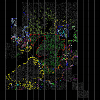
Data Overview, Gushemege Routes, Keyboard Controls
It's time for another look at the map's data/metadata coverage - the last one was back in 2006. Here is a dotmap render at 2 pixels/parsec showing all parsec-level borders and all routes:
 Notes:

- The rendering and encoding pipeline doesn't guarantee a single pixel per world, or even uniform brightness, so the dotmap should not be analyzed too closely - just gauge data density (i.e. "this is a rift" or "there's no data for this sector")
- This does not include Chtierabl or the Zhodani Core Route which, let's face it, is just a long, mostly straight line.
- Routes for Gushemege were added based on Traveller 1248 Sourcebook 2: Bearers of the Flame (download sector map in PDF format). I figure the Fourth Imperium xboat routes are probably pretty close to the Third Imperium xboat routes at least within the sector, since the backstory is that Usdiki Pocket fared pretty well. The edges of the sector - outside the 1248 4I borders - have sparse routes.
- You can now use the I, J, K and L keys to scroll the map as well as + and - to zoom in and out. This only applies to the main map page, not IFRAME embedded versions.
2007-12-27
We're out of beta - we're releasing on time!
I'm calling the credits experiment done, and out of beta. Shipped!
You'll now see metadata in the page footer for the area on which the map is centered - including world data if you're over an occupied parsec. The data shown will include:
Another feature that was in beta was a map legend, a new link in the lower left. This launches a popup window (your browser might block it) which uses the current map style to explain the details. (Question: with J-6 and unlimited fuel, how long would it take to get from Regina to Tertius?)
Also, I've added an experimental new API: /SEC.aspx?sector=SECTORNAME - this dumps a standard SEC file for the specified sector. The column widths are undefined - you'll want to use a regular expression to parse it.
Finally, per request on COTI, you will now see UWPs when zoomed in to 128 pixels/parsec. Ω
You'll now see metadata in the page footer for the area on which the map is centered - including world data if you're over an occupied parsec. The data shown will include:
- Sector Name
- World Hex
- World Name
- World UWP
- Sector Era
- Author
- Source
- Publisher
- Hyperlink to source of data
Another feature that was in beta was a map legend, a new link in the lower left. This launches a popup window (your browser might block it) which uses the current map style to explain the details. (Question: with J-6 and unlimited fuel, how long would it take to get from Regina to Tertius?)
Also, I've added an experimental new API: /SEC.aspx?sector=SECTORNAME - this dumps a standard SEC file for the specified sector. The column widths are undefined - you'll want to use a regular expression to parse it.
Finally, per request on COTI, you will now see UWPs when zoomed in to 128 pixels/parsec. Ω
2007-04-01
Metadata/Credits Preview and other Minor Updates
I've updated the code behind the site (both the server side and the client side). There aren't any dramatic changes noticeable by users, but there might be bugs - so let me know!
New stuff:
http://www.travellermap.com/index_creditstest.htm
As you scroll/zoom the map, world data and sector metadata (author, source, URL, etc) will be shown at the bottom of the page. The metadata isn't formatted in a particularly attractive way at the moment, nor is it complete, but this is the direction I'm planning to take with metadata. I may overlay the data on the map itself (lower right corner) rather than having it outside the frame - I'm not sure Ω
New stuff:
- You can now specify ?sector=name&hex=xxyy, for example: http://www.travellermap.com/?sector=Verge&hex=2612 - the page will automagically navigate for you, if it can find the sector. You can leave out the &hex=xxyy part too.
- MSEC.aspx and Poster.aspx now return an HTTP 404 error if they can't find the target sector, instead of defaulting to Spinward Marches
- Ran jslint.com over the client side scripts, and did some cleanup.
- Added preliminary sector data and metadata for Kaa G!'kul/Numbis based on work by Mike McKeown
- Created routes, cleaned up borders for Verge
- Trojan Reach, Riftspan Reaches and Ealiyasiyw borders cleaned up a bit
- Canopus subsectors added
http://www.travellermap.com/index_creditstest.htm
As you scroll/zoom the map, world data and sector metadata (author, source, URL, etc) will be shown at the bottom of the page. The metadata isn't formatted in a particularly attractive way at the moment, nor is it complete, but this is the direction I'm planning to take with metadata. I may overlay the data on the map itself (lower right corner) rather than having it outside the frame - I'm not sure Ω
2006-08-14
Solomani Borders
After a hiatus while moving my family down to San Francisco and lots of unpacking, I have cycles to do a little more work on the map now.
Now that I have my copy of Supplement 10 unpacked I've tackled borders for the Solomani Confederation, passing through the Solomani Rim, Alpha Crucis, Old Expanses, Spica, Langere (hello, Hivers!), Neworld, Aldebaran, Canopus, Ustral Quadrant, Dark Nebula, Reaver's Deep, Daibei and Magyar. I still need to tweak Daibei a bit.
For Aslan/Solomani and Solomani/Hiver borders I followed the conventions of Supplement 10 - the polities claim empty hexes between border worlds. This makes for more attractive borders, but at the expense of hand-tweaking.
Speaking of hand-tweaking (or wanting to avoid it), I've been playing with a different algorithm for allygen. Instead of starting with worlds within an allegiance and expanding outwards (which creates blobby regions of empty hexes), it starts big and contracts each region, snipping off "bad" hexes - empty hexes with three empty neighbors, and breaking up straight spans of 4 empty hexes, repeating until a minimal border is achieved. This yeilds very natural looking results. I'll publish a page on the algorithm soon.
For those sec2pdf fans out there I've added an MSEC generator - browse to http://www.travellermap.com/MSEC.aspx?sector=Solomani%20Rim and it'll spit out a rough .msec file for the specified sector based on my data. I haven't tested the result, yet, and it could use more work - e.g. grouping based on allegiance, etc. Ω
Subscribe to:
Posts (Atom)