A long time coming, but I finally wrote up slightly more human readable definition of the XML metadata format.
http://travellermap.com/doc/metadata
It doesn't explain everything, but should cover everything you actually need: borders, routes, allegiances, subsectors, labels, stylesheets, etc.
Ω
Showing posts with label borders. Show all posts
Showing posts with label borders. Show all posts
2014-11-22
2013-12-14
Luretiir!girr
I found an old dotmap, possibly by L. W. L. Guatney, that included a portion of K'kree space including one sector that no-one has tackled yet - Luretiir!girr.
I've generated a dotmap sec from it (i.e. only world positions, worlds are all nameless and X100000-0), and drew borders / picked allegiances based on the Imperium Map poster. This is totally unofficial but I thought it was worth preserving the dotmap data in case anyone decides to tackle the sector in the future.
I arbitrarily decided that the large polity jammed into the Spinward side of the Two Thousand Worlds was the Dominate of the Lords of Thunder, but it will be up to whoever officially defines the sector to identify the local governments and decide which, if any, is the Dominate. Ω
2013-06-08
Hive Federation Completed
Mark Humphreys has submitted the sector data, borders and routes for the last of the hitherto uncharted sectors of Hiver space, as well as updates to the other sectors, so it's all filled in on the map:
Ω
- Avereguar - new!
- Blaskon - new!
- Centrax
- Folgore - new!
- Gzirr!k'l
- Kidunal
- K'trekreer - new!
- Nooq - new!
- Porlock
- Ricenden
- Wrenton
Awesome work, Mark!
2013-03-21
Get your Hiver on
Thanks to exploration work by Mark Humphreys, three new sectors in Hiver space have come online including world data, borders and routes:
Ω
- Gzirr!k'l - straddling the Two Thousand Worlds and the Federation with a buffer zone of client states between. This sector bore the brunt of the Hiver/K'kree War in ages past, and bears the lingering scars.
- Ricenden - home to Guaran, the Hiver homeworld
- Centrax - home to Glea, the Federation capital
These aren't the final data or metadata, so expect some refinement over the coming months, and perhaps a few new sectors nearby.
(This is all unofficial data, of course. That will be obvious to long time visitors, but I'm going to try to be more explicit going forward given that I'm hosting both official and unofficial data without much distinction.)
2012-02-01
Rendering Fixes
Two quick rendering fixes.
- With "World Colors" checked, white-on-white worlds (e.g. Spinward Marches 0622 in Print style) should now have an outline
- Borders are now rendered as closed paths, which means small gaps near the "start" of each borders should be gone
The latter one was actually a substantial effort, but it's been sitting unpublished on my dev machine for some time now and I think I'm happy with the change.
Ω
2011-11-18
Beta Appearance Options
There are now some "hidden" appearance options. Scroll down the controls on the top left and you'll find three new "beta" options. All of these are experimental and could change or disappear at any time.
Force Hexes
This forces hexes to always be rendered... as hexagons. This applies at the 16 and 32 pixels/parsec scale. The map usually renders hexes as squares (well, rectangles) to match the Atlas of the Imperium and route maps printed in the Travellers Digest.
World Colors
An attempt at providing more information about worlds. This currently only applies at the 64 pixels/parsec and up. The color codes are currently:
- Rich and Agricultural: gold •
- Agricultural: green •
- Rich: purple •
- Industrial: gray •
- Corrosive/insidious/etc: rust •
- Vacuum: black •
- Liquid water: blue •
- Otherwise: white ○
Filled Borders
As previous discussed. It's pretty, you should try it out. This only applies when micro-scale borders are rendered - i.e. 4 pixels/parsec and up.
These features haven't been extensively tested and may not make sense in all styles. Feedback is very much appreciated.
Ω
2011-11-12
Sneak Preview: Filled Borders
Sneak preview of the "filled border" functionality:

This is still only a 99% solution - there are tiny gaps when using "candy style" borders near sector boundaries, where a few pixels inside the border might not be filled. Only noticeable if you go looking, and fixing that would be extremely computationally expensive, so I probably won't bother. Other minor issues include overlapping polities such as the Vegan Autonomous District (Spinward Marches), Ral Ranta (Hinterworlds), and the sub-polities of the Julian Protectorate - the translucent backgrounds blend. Also, world names (and the worlds themselves) have a black background - I may try and fix that.
This will be controlled by an option/parameter, but I haven't hooked that up yet.
One issue is that this makes the polities without micro-scale borders - namely, the Hive Federation and Two Thousand Worlds - more glaringly incomplete. I could toss in "make this entire sector purple/green" placeholders like I did for Stiatlchepr. Opinions? Ω
2011-11-01
Metadata Tweaks
Some minor cleanup:
- Tweaked label positions for: Foreven, Beyond, Touchstone, Riftspan Reaches, Reaver's Deep, Dark Nebula, Ustral Quadrant
- Tweaked borders for: Reaver's Deep, Daibei, Dark Nebula
- Tweaked polity names for: Reaver's Deep (per Sector Sourcebook)
- Added travel zones to Reaver's Deep (per Sector Sourcebook)
- Made the sector.htm demo page show polity names on the "centerfold" map
Ω
2011-10-24
Cleanup & Border Updates
Mish-mash of updates:
- At some point recently I broke the default state of the flag controlling rendering of local polity names so they should now by default to rendering again.
- I dusted off the border calculation code (doc, demo):
- Added a page that will generate borders for a map sector considering the 8 adjacent sectors. Try it. Sorry, doesn't work with uploaded sectors yet, but that should be easy to make work.
- Fix border walk termination logic (would leave in a duplicate hex if the polity had a vertical left edge)
- Added heuristic for bridging 1pc gaps in polities
- The SEC API now optionally accepts sx/sy coordinates instead of sector (name)
- Work around what looks like a Chrome 14 bug with object creation. var o = {}; o.x = 'foo'; was claiming that the property was read only in some cases.
- Updated borders for: Fa Dzaets, Trenchans, Gvurrdon, Tuglikki, Mendan, Amdukan, Deneb, Corridor, Solomani Rim
2009-02-27
Data Overview 2009
At the start of 2008 I posted a data overview, showing how much things had changed since 2006. This should probably become a yearly tradition, so here's the official 2009 overview:
Not a whole lot of change. So far as I can tell by doing a "blink compare", at this scale the only differences are:
Anything else I can plug in, dear readers?
(I used TortoiseIDiff to do the blink comparison. I used a similar technique while doing the Solomani and Aslan Dotmap Reconstruction.) Ω

Not a whole lot of change. So far as I can tell by doing a "blink compare", at this scale the only differences are:
Anything else I can plug in, dear readers?
(I used TortoiseIDiff to do the blink comparison. I used a similar technique while doing the Solomani and Aslan Dotmap Reconstruction.) Ω
2008-03-06
Border Generation
I've written up a paper and demo page on the updates to the allygen algorithms by J. Greely I used to generate most of the borders that weren't previously documented.
The modified allygen code I used isn't terribly pretty, but is available on request. I'd like to clean it up before publishing it. The demo version is reimplemented in JavaScript and is much easier to read. I encourage you to check out the source.
Would a full blown web app that lets you copy/paste .SEC files and interactively generate border descriptors (useful for sec2pdf ) be useful for anyone? Ω
2008-01-26
Data Overview, Gushemege Routes, Keyboard Controls
It's time for another look at the map's data/metadata coverage - the last one was back in 2006. Here is a dotmap render at 2 pixels/parsec showing all parsec-level borders and all routes:
 Notes:

- The rendering and encoding pipeline doesn't guarantee a single pixel per world, or even uniform brightness, so the dotmap should not be analyzed too closely - just gauge data density (i.e. "this is a rift" or "there's no data for this sector")
- This does not include Chtierabl or the Zhodani Core Route which, let's face it, is just a long, mostly straight line.
- Routes for Gushemege were added based on Traveller 1248 Sourcebook 2: Bearers of the Flame (download sector map in PDF format). I figure the Fourth Imperium xboat routes are probably pretty close to the Third Imperium xboat routes at least within the sector, since the backstory is that Usdiki Pocket fared pretty well. The edges of the sector - outside the 1248 4I borders - have sparse routes.
- You can now use the I, J, K and L keys to scroll the map as well as + and - to zoom in and out. This only applies to the main map page, not IFRAME embedded versions.
2008-01-25
What's Missing?
Apart from dorking around with experiments, the actual content of the site is reasonably stable. So I was pondering... what's missing? What are the gaps in the data that we should endeavor to fill in? Let me throw that question out to the readers.
Off the top of my head:
This is a subtly different question than "what should I do next?" - I'll post an updated roadmap soon for comments. Ω
Off the top of my head:
- Borders in K'kree space
- Borders in Hiver space
- Coreward half of Far Frontiers (I have an email out to James Kundert)
- Routes in Ilelish, Zarushagar, Gushemege, Delphi, Alpha Crucis
This is a subtly different question than "what should I do next?" - I'll post an updated roadmap soon for comments. Ω
2008-01-12
Border Cleanup
A minor bit of cleanup:
I have reports that dragging is no longer working in IE6 on WinXP since an update circa Jan 1st, but I can't reproduce the problem. Can anyone else? If so, tracking down the problem should be easy. Ω
- Found and fixed a bug with candy-style border rendering along sector boundaries. Most notable in the Vargr Extents
- Regenerated borders for Khoellighz, Windhorn, Mendan, Vland, Lishun, Antares, and tweaks in a few other sectors to make edges line up
I have reports that dragging is no longer working in IE6 on WinXP since an update circa Jan 1st, but I can't reproduce the problem. Can anyone else? If so, tracking down the problem should be easy. Ω
2007-08-11
Metadata and Legend
Updates to "beta" version of the page that includes data and credits for location the map is centered on:
The "beta" version of the page mentioned here is out of beta. Ω
- Click on Control box just inside the border to hide it
- Tweak the formatting of metadata
- Added a link to a Map Legend - feedback appreciated!
- Fix location of Lesser Rift label
- Tweak UWP parser regex to catch travel zones w/ no base or codes - Clan (1103 Spinward Marches) wasn't showing as an Amber Zone
- Added subsector names for: Provence, Windhorn, Meshan, Astron, Fulani, Theta Borealis, Theron, Iphigenaia, Touchstone, Delphi, Karleaya, Alpha Crucis, Spica, Uistilrao, Aldebaran, Neworld, Banners, Hanstone, Malorn, Hadji, Storr
- Labels now render on top of routes (doesn't obscure the text)
- Precise borders are now shown at scale 4 and higher (i.e. as soon as you zoom in)
- Borders are now thicker at maximum zoom
The "beta" version of the page mentioned here is out of beta. Ω
2007-04-01
Metadata/Credits Preview and other Minor Updates
I've updated the code behind the site (both the server side and the client side). There aren't any dramatic changes noticeable by users, but there might be bugs - so let me know!
New stuff:
http://www.travellermap.com/index_creditstest.htm
As you scroll/zoom the map, world data and sector metadata (author, source, URL, etc) will be shown at the bottom of the page. The metadata isn't formatted in a particularly attractive way at the moment, nor is it complete, but this is the direction I'm planning to take with metadata. I may overlay the data on the map itself (lower right corner) rather than having it outside the frame - I'm not sure Ω
New stuff:
- You can now specify ?sector=name&hex=xxyy, for example: http://www.travellermap.com/?sector=Verge&hex=2612 - the page will automagically navigate for you, if it can find the sector. You can leave out the &hex=xxyy part too.
- MSEC.aspx and Poster.aspx now return an HTTP 404 error if they can't find the target sector, instead of defaulting to Spinward Marches
- Ran jslint.com over the client side scripts, and did some cleanup.
- Added preliminary sector data and metadata for Kaa G!'kul/Numbis based on work by Mike McKeown
- Created routes, cleaned up borders for Verge
- Trojan Reach, Riftspan Reaches and Ealiyasiyw borders cleaned up a bit
- Canopus subsectors added
http://www.travellermap.com/index_creditstest.htm
As you scroll/zoom the map, world data and sector metadata (author, source, URL, etc) will be shown at the bottom of the page. The metadata isn't formatted in a particularly attractive way at the moment, nor is it complete, but this is the direction I'm planning to take with metadata. I may overlay the data on the map itself (lower right corner) rather than having it outside the frame - I'm not sure Ω
2006-10-19
Vargr Allegiances and Rimward States
Done! I've now generated borders for every sector. Of course, some still need tweaking... but I think I'll take a break now.
Most recent changes:
"The borders of the Julian Protectorate are not easy to define..." - Michael R. Mikesh, Challenge #49
No kidding!
Take a peek at how I did it, and let me know what you think. Ω
Most recent changes:
- Added borders for: Ohieraoi, Fahreahluis, Hfiywitir, Irlaftalea, Teahloarifu, Ahkiweahi', Iyiyukhtoi', Banners, Hanstone, Malorn, Hadji
- Added allegiance codes from Vilani and Vargr
- Show labels for regions even if they're standard allegiances (e.g. "Im", "Zh", etc)
- Added labels for J-4 and J-5 rift spanning routes (micro-scale)
- Added allegiance code for Regency of Muirimi (Theron and Iphigenaia)
- Corrected allegiances of Eha and Yuhoahtiyol (Hanstone Sector) to match Solomani and Aslan
"The borders of the Julian Protectorate are not easy to define..." - Michael R. Mikesh, Challenge #49
No kidding!
Take a peek at how I did it, and let me know what you think. Ω
2006-10-17
Vargr Extents - Borderific!
No hyperlinks today - find your own damn sectors!
Borders for:
Parser changes (i.e. look for corrected allegiances):
Borders for:
- Vargr Extents: Khoellighz, Dhuerorrg, Ngathksirz, Fa Dzaets, Gzaefueg, Gvurrdon, Tuglikki, Provence, Windhorn, Meshan, Rzakki, Listanaya, Ksinanirz, Zao Kfeng Ig Grilokh, Knaeleng, Kharrthon, Oeghz Vaerrghr, Kfazz Ghik
- Gashikan Empire: Gashikan, Trenchan
- Julian Protectorate: Mendan, Amdukan, Ingukrax (Arzul), Antares, Empty Quarter, Star's End
- Vargr Enclaves: Ktiin'gzat, Mugheen't
- Zhodani Consulate: Zhodane
- Spinward States: Fulani, Theron, Iphigenaia, Touchstone
Parser changes (i.e. look for corrected allegiances):
- Force PBG to be digits (0-9, 0-F, 0-F) to avoid matching stellar data "G5V DM" as PGB/Allegiance
- Tweaked regex to match "JP/" prefix on allegiances (Julian Protectorate)
- "olive" back to "olivedrab" (used for Vargr regions)
2006-10-12
Data Cleanup and K'kree/Hiver borders
A few more borders in Hiver and K'kree space:
- Added borders for Gn'hk'r (Gelath) and Gh!hken
- Added allegiances and generated borders for Leonidae and Extolian
- Reworked Hinterworlds borders to connect with Leonidae
I noticed in some of the “outlying” sectors (i.e. non GEnie data) that the UWP parser was misinterpreting some worlds (e.g. thinking the PBG was a trade code, the allegiance was PBG, and the stellar data was the allegiance) or missing some worlds entirely. This is because when I started I used a very loose pattern matching system to try and incorporate lots of different data sets without editing the sector data itself. This turns out to be intractable, so I’ve given up and tweaked the data in some sectors to be a little less quirky, and tightened up the parser. The site should also be marginally faster in loading data (i.e. if no-one has viewed a region in a few seconds).
Data tweaks:
- Replaced blank allegiances with -- in Leonidae
- Fixed badly generated PBGs for Uu (Teahloarifu 0319) and Ukhihesi (Teahloarifu 1431)
- Added spaces to Extolian and Ktiin’gzat sector data for correct Zone and PBG parsing
- Fixed PBGs for Foreven (blank B to 0)
- Arkadish (Mendan 0515)
- Unnamed (Zhdant 1206)
- Khipge (Zarushagar 0914)
- Strand (Gushemege 0237) - missing digits in GEnie data; used Core data
- Ninkhur Sagga (Solomani Rim 2222) - replaced blank PBG with 100
2006-10-09
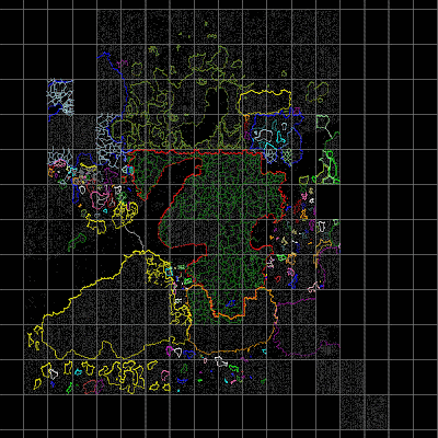
How is the metadata coming?

I made a tweak to the renderer to use the "micro-scale" borders at macro-scale to create the above picture, which shows how many borders have been generated so far. My goal is to switch to using the generated borders (sufficiently smoothed and merged with hand-drawn borders) at some point. They'll stay red at the large scale.
I'm actually farther along that it looks - very little of the Hive Federation or 2000 Worlds has been mapped out. There are a few more sectors in the Spinward and Trailing client states that need border generation, and of course the Vargr Extents. Ω
Subscribe to:
Posts (Atom)